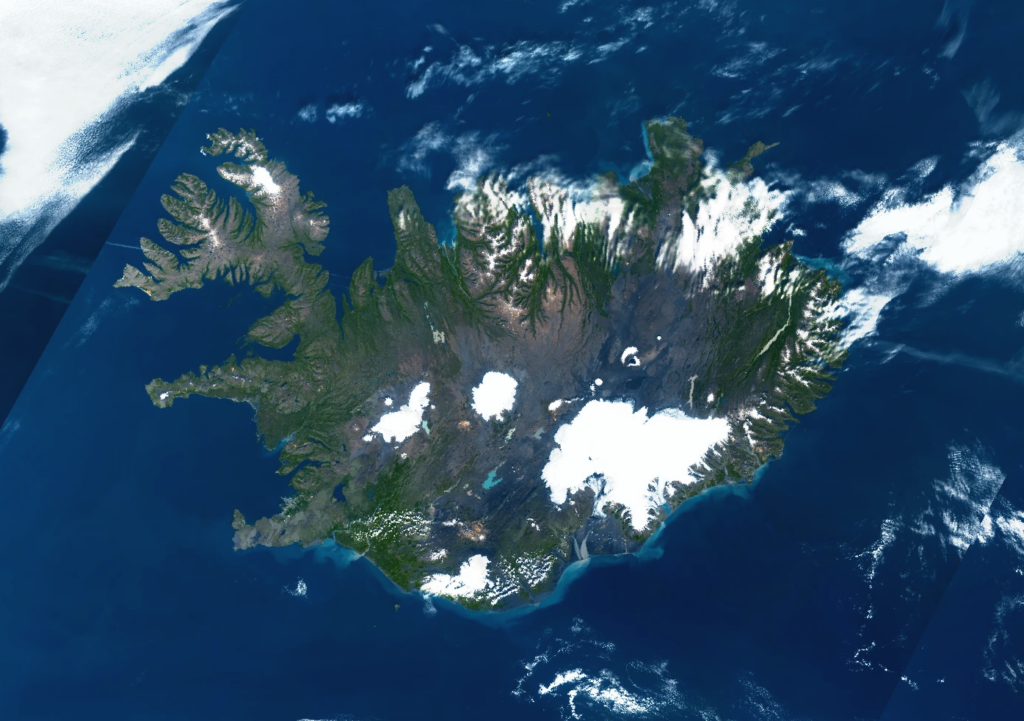

Sjaldgæf, nær skýjalaus sýn yfir Ísland frá Sentinel-3
Ísland sést ekki oft alveg óhulið úr geimnum. Þann 10. ágúst 2026 véku skýin hins vegar að mestu til hliðar.
Þessi glæsilega Copernicus Sentinel-3 gervitunglamynd sýnir nær skýjalaust Ísland og gefur einstaka sýn á hið fjölbreytta landslag landsins úr geimnum.
Þar sem skýjahula er lítil sjást mörg helstu einkenni Íslands sérstaklega vel: víðáttumiklir jöklar og íshellur, dökk eldfjallasvæði, hrikaleg strandlengja, hálendið og hafið umhverfis landið.
Sentinel-3
Copernicus Sentinel-3 gervitunglaverkefnið er hannað til að fylgjast bæði með landi og hafsvæðum.
Mælitæki þess veita upplýsingar meðal annars um lit hafsins, yfirborð lands, yfirborðshita, gróður, ís og ýmsa aðra þætti jarðkerfisins.
Sentinel-3 nýtist því ekki aðeins til að taka tilkomumiklar myndir af jörðinni heldur einnig til umhverfisvöktunar og vísindalegra rannsókna.
CDSE
Hægt er að skoða Copernicus gervitunglagögn í gegnum Copernicus Data Space Ecosystem, eða CDSE.
CDSE veitir ókeypis og opinn aðgang að jarðfjarkönnunargögnum frá Copernicus Sentinel gervitunglunum, þar á meðal Sentinel-3.
Ein einfaldasta leiðin til að byrja er að nota Copernicus Browser. Þar geta notendur leitað að ákveðnu svæði, skoðað tiltækar gervitunglamyndir, borið saman mismunandi dagsetningar og hlaðið niður gögnum.
Reyndari notendur geta einnig nálgast Copernicus gögn í gegnum þjónustur og forritaskil sem henta fyrir sjálfvirka úrvinnslu og umfangsmikil jarðfjarkönnunarverkefni.
Skoðaðu Copernicus Data Space Ecosystem og sjáðu hvað Sentinel gervitunglin hafa myndað yfir þínu svæði.

A Rare Cloudless View of Iceland from Sentinel-3
Iceland does not often reveal itself completely from space. On 10 August 2026, however, the clouds largely stepped aside.
This remarkable Copernicus Sentinel-3 observation captures an almost cloudless view of Iceland, offering a striking look at the island’s extraordinary landscape from orbit.
With so little cloud cover obscuring the surface, many of Iceland’s defining features become clearly visible: vast ice caps and glaciers, dark volcanic terrain, rugged coastlines, highlands, and the surrounding waters of the North Atlantic.
Sentinel-3
The Copernicus Sentinel-3 mission is designed to monitor both land and oceans. Its instruments provide observations related to ocean colour, land surfaces, surface temperature, vegetation, ice, and many other components of the Earth system.
Sentinel-3 is therefore useful not only for producing impressive views of our planet, but also for environmental monitoring and scientific analysis.
Copernicus Data Space Ecosystem
Copernicus satellite data can be explored through the Copernicus Data Space Ecosystem, or CDSE.
CDSE provides free and open access to Earth observation data from the Copernicus Sentinel missions, including Sentinel-3.
One of the easiest ways to begin is with the Copernicus Browser, where users can search for a location, explore available satellite acquisitions, compare different dates, and download imagery.
More advanced users can also access Copernicus data through services and APIs designed for automated processing and large-scale Earth observation workflows.
Explore the Copernicus Data Space Ecosystem and discover what the Sentinel satellites have captured over your part of the world.